A new navigation system that tracks the subatomic particles that are constantly bombarding the Earth could help us get around indoors, underground and underwater—everywhere GPS doesn’t work.
challenge: The Global Positioning System (GPS) is a group of 31 satellites that continuously transmit radio signals approximately 12,500 miles above Earth’s surface. Receivers in phones, cars, planes, and ships use data from multiple satellite signals to calculate their position on Earth.
“Using muons, we have developed a new kind of GPS that works underground, indoors and underwater.”
Hiroyuki Tanaka
While GPS has revolutionized ground transportation, satellite signals can reflect off hard surfaces, making it impossible for navigation systems to pinpoint the receiver’s position indoors, underground and underwater.
GPS signals can be jammed or spoofed. The military and cybercriminals can use it to damage GPS systems or cause receivers to display inaccurate information.
Explore space: Researchers at the University of Tokyo have now developed a new type of navigation system whose receiver detects, rather than satellite signals, muons, subatomic particles created by collisions between cosmic rays and particles in Earth’s atmosphere.
Researcher Hiroyuki Tanaka said: “The cosmic ray muons fall equally all over the Earth and always travel at the same speed across any material, penetrating many kilometers of rock.”
“Now, using Muon, we have developed a new kind of GPS called muPS (muometric positioning system) that works underground, indoors and underwater.”
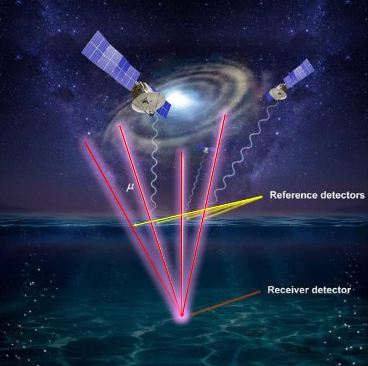
You can find a receiver by looking at the distance between the receiver and multiple reference detectors.
How it works: A muPS system requires a receiver and several “reference detectors” located above it. The time it takes muons to travel through the reference detector to the receiver can be used to determine the distance between them.
The position of the receiver can then be triangulated by determining the distance between the receiver and several reference detectors.
Unveiled in 2020, the UTokyo team’s first iteration of the navigation system is designed to monitor changes in the seabed and demonstrated that the coordinates of an underwater receiver can be determined through computer simulations.
However, the receiver had to be connected via wire to a floating station, which limited its movement.

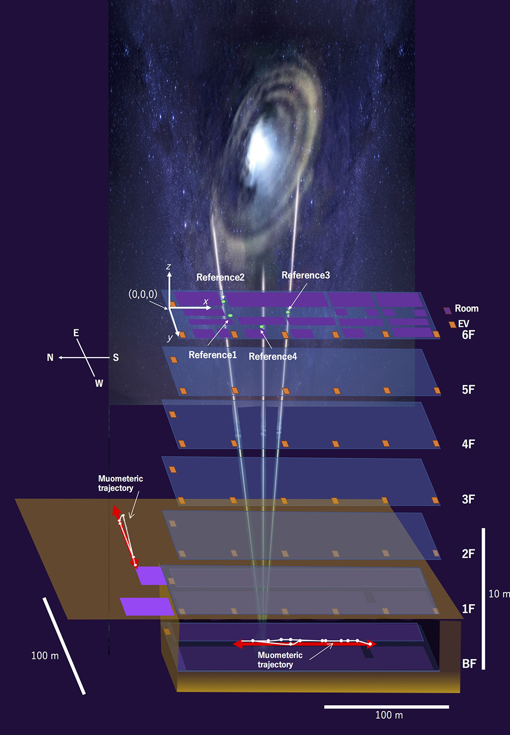
In a recent study published in iScience, the team demonstrated a wireless version of the technology called “mumetric wireless navigation system” (muWNS).
This time we placed the reference detector on the 6th floor of the building. The person carrying the receiver walked along an underground corridor, and using the reference detector and the receiver’s readings, the scientists were able to recreate their path.
cold water: The new navigation system did not work in real time and there is still a lot of room for improvement in terms of accuracy.
“Currently, the accuracy of MuWNS is between 2 and 25 meters, with ranges up to 100 meters depending on the depth and speed of the walker,” Tanaka said. “[This] It is still far from the level of practical use. People need 1 meter accuracy.”

Looking ahead: Tanaka believes that integrating chip-scale atomic clocks (CSACs) into MuWNS will enable real-time measurements with 1-meter accuracy, but the technology is currently out of reach for his team.
“CSAC is already commercially available and is double-digit better than the quartz watches we use today,” he explained. “[T]They are too expensive for our use right now, but as global demand for CSACs for mobile phones increases, we expect them to become even more affordable.”
If CSAC becomes commonplace in phones and other consumer technologies, the other components MuWNS will need can already be made small enough to fit on the device. This means that one day carrying a muon detection receiver with you wherever you go may become commonplace.
This can be very useful after a disaster where people are trapped underground or under rubble. As Tanaka told Freethink, flying a drone equipped with a reference detector over an area will allow first responders to identify the location of buried cell phones and the people carrying them with centimeter-level accuracy.
We’d love to hear from you! If you have comments about this article or tips for future Freethink stories, please email us at: [email protected].
#navigation #system #built #spacecraft #work #GPS #fails